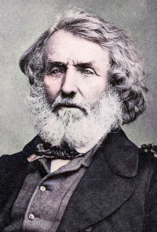
Sir George Everest (1790-1866)
On July 4, 1790, Welsh military engineer and geodesist Sir George Everest was born. Everest was the Surveyor General of India from 1830 through 1843, providing the accurate mapping of the subcontinent. For more than twenty-five years and despite numerous hardships, he surveyed the longest arc of the meridian ever accomplished at the time. In 1865, Mount Everest was named in his honour in the English language, despite his objections, by the Royal Geographical Society.
George Everest – Early Years
Everest was born in Gwernvale Manor, just west of Crickhowell in Brecknockshire, Wales, in 1790, and he was baptised in Greenwich. In 1806 he went to the Military Academy at Woolwich where he excelled at maths and, in particular, at trigonometry. Studies complete, he joined the East India Company and served the next seven years in Bengal. During the British occupation of the Dutch East Indies, Everest worked on the survey of Java (1814–16) under Sir Stamford Raffles, the creator of Singapore, and then returned to India.[1,2] Commissioned into the Royal Artillery, in 1818, Lt. Everest was appointed as assistant to Colonel William Lambton, who had started the Great Trigonometrical Survey of the Indian subcontinent in 1806.
Measuring the Indian Territory
From its inception in 1600 to the beginning of the nineteenth century, the British East India Company had gained more territory on the Indian subcontinent. With the acquisition of new territory, it employed several explorers and cartographers to provide maps and other information on its territories, most notably English geographer, historian and a pioneer of oceanography James Rennell, from 1767 in Bengal. As Rennell proceeded making maps, some serious flaws in them surfaced, based on a lack of precise measurements. It was a mammoth task that, with the primitive theodolites was expected to last many years. Triangulation surveys were based on a few carefully measured baselines and a series of angles. The initial baseline was measured with great accuracy, since the accuracy of the subsequent survey was critically dependent upon it. It took 57 days to measure the 12-km base line, using giant theodolites, each weighing 500 kg and requiring 12 men to carry. Various corrections were applied, principally temperature. An especially accurate folding chain was used, laid on horizontal tables, all shaded from the sun and with a constant tension. The early surveys made use of large and bulky theodolites made by William Carey, a Zenith sector made by Jesse Ramsden and 100-foot chains. Later surveys used more compact theodolites.
Superintendent of the Geographical Survey
On Lambton’s death in 1823, Everest succeeded to the post of superintendent of the survey, and in 1830 with the survey still underway, he was appointed as the Surveyor-General of India. Everest was always an innovator and during his time on the survey as Surveyor General of India he made many modifications and alterations to the equipment used.[2] When the survey reached the Himalayan foothills by the 1830s, Nepal was unwilling to allow the British to enter the country due to suspicions of political aggression and possible annexation. Several requests by the surveyors to enter Nepal were turned down. The British were forced to continue their observations from Terai, a region south of Nepal which is parallel to the Himalayas. Conditions in Terai were difficult because of torrential rains and malaria. Three survey officers died from malaria while two others had to retire because of failing health.
The Peaks of Himalaya
Nonetheless, in 1847, the British continued the survey and began detailed observations of the Himalayan peaks from observation stations up to 240 km distant. Kangchenjunga was then considered the highest peak in the world, and with interest the surveyor team noted a peak beyond it, about 230 km away. In 1852, stationed at the survey headquarters in Dehradun, Radhanath Sikdar, an Indian mathematician and surveyor from Bengal, was the first to identify Everest as the world’s highest peak, using trigonometric calculations. British army officer and successor of Everest as Surveyor General of India Andrew Scott Waugh along with his staff spent almost two years working on the numbers, having to deal with the problems of light refraction, barometric pressure, and temperature over the vast distances of the observations. Finally, in March 1856 he announced his findings in a letter to his deputy in Calcutta. Kangchenjunga was declared to be 8,582 m, while Peak XV – the aformentioned higher peak beyond – was given the height of 8,840 m. Waugh concluded that Peak XV was “most probably the highest in the world“.
![Aerial photo from the south, with Mount Everest rising above the ridge connecting Nuptse and Lhotse, By Mount_Everest_as_seen_from_Drukair2.jpg: shrimpo1967 derivative work: Papa Lima Whiskey 2 [CC BY-SA 2.0 (http://creativecommons.org/licenses/by-sa/2.0)], via Wikimedia Commons](http://scihi.org/wp-content/uploads/2017/07/Mount_Everest_as_seen_from_Drukair2_PLW_edit-600x326.jpg)
Aerial photo from the south, with Mount Everest rising above the ridge connecting Nuptse and Lhotse, By shrimpo1967 derivative work: Papa Lima Whiskey 2, CC BY-SA 2.0, via Wikimedia Commons
From Peak XV to Mt. Everest
While the survey wanted to preserve local names if possible (e.g., Kangchenjunga and Dhaulagiri), Waugh argued that he could not find any commonly used local name. Waugh argued that because there were many local names, it would be difficult to favour one name over all others, so he decided that Peak XV should be named after Sir George Everest, his predecessor as Surveyor General of India. Everest himself opposed the name suggested by Waugh and told the Royal Geographical Society in 1857 that “Everest” could not be written in Hindi nor pronounced by “the native of India”. Waugh’s proposed name prevailed despite the objections, and in 1865, the Royal Geographical Society officially adopted Mount Everest as the name for the highest mountain in the world
Everest had retired in 1843 and returned to the UK, where he became a Fellow of the Royal Society. He was dubbed a knight in 1861, and in 1862 he was elected as the vice-president of the Royal Geographical Society. George Everest died in London in 1866.
The Call of Everest | Conrad Anker | Talks at Google, [8]
References and Further Reading:
- [1] Sir George Everest, British Geodesist, at Britannica Online
- [2] Phil Carradice: Sir George Everest, at BBC Wales, June 13, 2011.
- [3] “Because it’s there” – George Mallory and Mount Everest, SciHi Blog
- [4] Edmund Hillary and Tenzing Norgay on Top of Mount Everest, SciHi Blog
- [5] Chisholm, Hugh, ed. (1911). . Encyclopædia Britannica (11th ed.). Cambridge University Press.
- [6] Sir George Everest at Wikidata
- [7] Sir George Everest at Reasonator
- [8] The Call of Everest | Conrad Anker | Talks at Google, Talks at Google @ youtube
- [9] Timeline of British Geographers, via DBpedia and Wikidata

Pingback: Whewell’s Gazette: Year 3, Vol. #47 | Whewell's Ghost